Kiewa: Encountering the Hydroelectric Margins

Contour Relief Map
Bogong High Plains and Upper Kiewa Valley, Jonathan Russell, 2020
Stand in the centre a while and consider the edge. From 699 Bourke Street in Melbourne’s CBD, the view stretches west towards the horizon and the urban boundary. But where is the edge of Melbourne? Is there a hard outer limit to the city, or is this edge greyer, less easily defined? Like every city, Melbourne occupies a specific geographic context - a broad hinterland in which human and natural systems mix in varying proportions. Studies of urban metabolism have sought to quantify these relationships, measuring the movements of matter and energy as a proxy for the relationship between a city and its surroundings.¹ This quantitative method, while useful, tells us little about the nature of the boundaries created by the interaction of city and hinterland. It is difficult to interrogate the edge from the centre - instead, we need to follow the capillaries that spread across the landscape, long threads that tie the city into its context. The office building at 699 Bourke Street is the near end of one such thread. In a control centre here AGL, Australia’s largest energy company, remotely operates ten hydroelectric power plants spread throughout Victoria.² Primary amongst these is the Kiewa Hydroelectric Scheme, located in the Alpine National Park more than 300 kilometres northeast of Melbourne. First proposed in 1911 and constructed between 1938 and 1961 (with further additions in 2009),³ the Kiewa Scheme remains Victoria's largest hydroelectric power source.⁴ In Victoria the vast majority of power is generated far from Melbourne, its predominant consumer. Every light switch in every household here is directly, physically connected to this far-flung system of generators through a network of conduits, transformers and high-voltage power lines. These generators in turn are operated from control rooms like the one here on Bourke Street - functionally, the power station is a remote appendage of the city, the far-flung reaches of an urban border. What happens at this edge? When natural and artificial systems are superimposed, what kind of hybrid landscape emerges?
The terms boundary and border are sometimes used interchangeably, however there is value in untangling the two. Taking his cue from biologist Steven Gould, Richard Sennett writes that “The boundary is an edge where things end; the border is an edge where different groups interact.”⁵ Sennett applies these concepts to questions of urban planning, but they provide a useful framework for interrogating any edge condition, including the margins of a city: if the edge between inside and out is solid, easily defined and exclusionary it is a boundary. If the edge is porous, allowing for interaction between inside and out, it is a border. While not universally adhered to in the literature, the difference between a hard and porous edge is key to understanding the relationship between the city, the Kiewa Scheme and the wilderness beyond.
The Kiewa Valley is a picturesque region four hours northeast of Melbourne at the foot of Mount Bogong, Victoria’s highest peak. The area has been inhabited for thousands of years by its traditional owners, with graziers and gold prospectors first arriving in the 1850s.⁶ The valley’s largest settlement, Mount Beauty, is much younger - it was founded in 1946 by the State Electricity Commission (SEC) as a state-run model town, closed off for years to the outside world. The SEC, a state government entity, was the controlling authority for electricity in Victoria from 1921 to 1993. For much of this period the Commission planned, constructed and operated all of the state’s electrical infrastructure, including the Kiewa Hydroelectric Scheme. Today Mount Beauty remains the gateway to the Bogong High Plains and the monumental power-generating infrastructural complex spread across these mountains.
In Organisation Space, Keller Easterling profiles Benton MacKaye, a 20th century American planner and theorist of infrastructure. Mackaye was influential in the early years of the Tennessee Valley Authority, a depression-era superproject with interesting parallels to the Kiewa Scheme. Specifically, the TVA illustrates Mackaye’s interest in conceptualising space as defined by functional relationships rather than political boundaries. In Mackaye’s ideal, for any given system, “the external boundary criteria depended on an emanating generative activity and was often an elastic condition.”⁷ The relationship between Melbourne and the Kiewa Scheme can be thought of through this lens. In Easterling’s terms, the emanating generative activity was Melbourne’s burgeoning demand for power. This led the city, under the auspices of the SEC, to reach out into its hinterland and the Kiewa Valley. The border between inside and outside the city is, again as per Easterling, an elastic condition: the functional relationship (power generation and transmission) between the Kiewa Valley and Melbourne allows us to see them as a single, connected entity despite their physical separation.
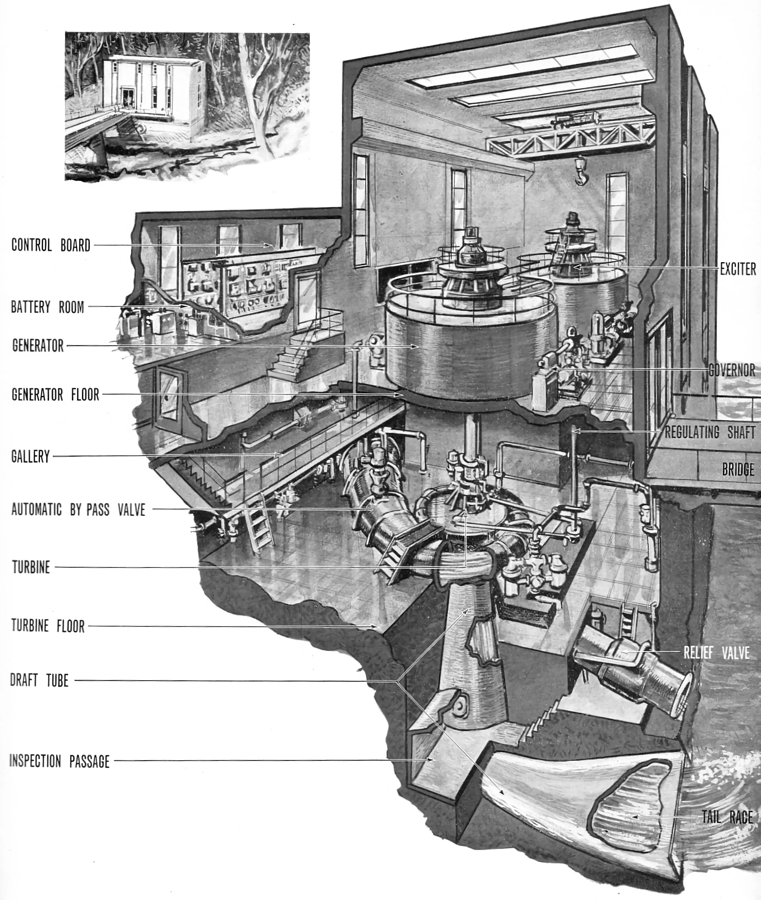
Figure 1.
Diagram of Clover Power Station, SECV, 1949
The Bogong High Plains Road winds out of Mount Beauty and into the Alpine National Park. The valley narrows and folds as it climbs, and soon the view is of tall Alpine Ash forests laid across the gullies and foothills of Mount Bogong - archetypal Australian wilderness. A quarter hour’s drive out of town the road dips to meet the Kiewa River, and an incongruous site emerges from the bush. A concrete bridge crosses the river to an industrial building nestled in a forested gully. This is Clover Power Station, completed in 1945 and the oldest of the four generators in the Kiewa Scheme. (Fig. 1) Built during the Second World War, it is functional and unadorned but architecturally rigorous, clad mostly in corrugated fibre-cement sheet due to war-time concrete shortages.⁸ Clover is the most visible of the four stations in the scheme, the others being mostly buried underground. It is a large, almost brutal building but here - enveloped by forest in the steep foothills - it is dwarfed by its context. A short way downstream, Clover Dam is similarly inconspicuous. (Fig. 2) A reinforced concrete gravity dam built in 1954, in the years since the bush has regrown and surrounded it, the ogee profile of the dam wall stained and spotted with moss. This is an integral, still-functioning part of the Kiewa Scheme, but time has softened it into its context, and today an abandoned atmosphere pervades the place.

Figure 2.
Clover Dam, Jonathan Russell 2020
It is worth pausing here to consider the name and nature of the Kiewa Hydroelectric Scheme, and dwelling particularly on the idea of a hydroelectric scheme. Hydroelectric power generation dates back to the 1870s and has existed in Australia since at least 1895.⁹ The basic operation in all cases is the same: transmuting gravitational potential energy into electricity. Water at some high point falls by force of gravity and is directed at pressure towards a turbine. The momentum of the falling water rotates the turbine, which is connected to a generator. Powerful magnets in the generator convert this kinetic energy into electricity that feeds into the wider grid. The generating capacity of any hydroelectric system is driven by two fundamental variables - the volume of water passing through the system and the vertical distance that water falls. Prior to construction of the Kiewa Scheme, officials from the State Electricity Commission conducted study tours, including to North America during construction of the massive Hoover and Grand Coulee dams.¹⁰ These dams, along with most of the world’s largest hydroelectric projects, collect and generate electricity at a single site. In this configuration, water is released to turbines either inside or below one large dam, with the overall drop (and hence the energy of the water) equal to the height of the dam. The Kiewa Scheme operates somewhat differently. The East and West Branches of the Kiewa are low volume, fast-flowing rivers that drain a mostly-flat mountain plateau, the Bogong High Plains. From top to bottom the Kiewa Scheme falls around 1200 metres, but no single power plant harnesses the energy of the whole drop. Instead, water passes from dam to tunnel to turbine before flowing to the next station at a lower elevation, repeating the process to turn as many as four generators on its way down the valley. The SEC’s 1960s-era illustration of the scheme is a useful guide to this sequence. (Fig. 3) On the High Plains, Pretty Valley and Rocky Valley reservoirs collect streams and seasonal snowmelt and pass the water through a tunnel and pipeline to the underground Mackay Creek Power Station (No. 1). Water released from the Mackay Creek Station is diverted underground to Bogong Power Station, long planned but only completed in 2009 (No. 2). Bogong’s release is captured behind Junction Dam and released by underground pipeline to Clover Power Station (No. 3), its incongruous above-ground generator hall dwarfed by the surrounding mountains. Clover Station releases to the adjacent Clover Dam, which diverts water to West Kiewa Station (No. 4), buried 140 metres below ground. The Kiewa, then, is not any single place or facility, but a Scheme: an integrated yet diffuse infrastructural complex, with individual components scattered throughout the mountain landscape. Why does Clover Station seem so dwarfed? At least in part because the Kiewa Scheme is a stealthy kind of infrastructure: its component parts are spread so widely across the landscape that it is never perceived all at once.
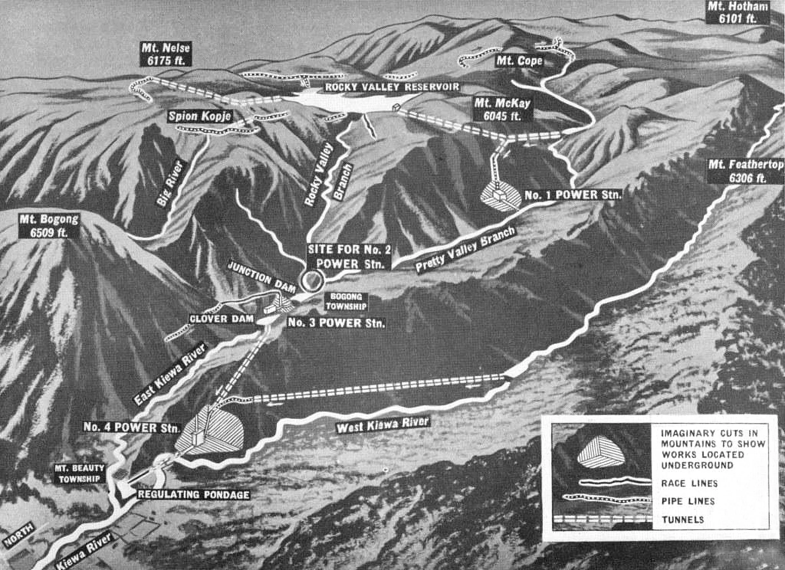
Figure 3.
Diagram of Kiewa Hydroelectric Scheme, SECV, c. 1960
Fundamentally, the Kiewa Scheme is driven by the natural hydrology of the Bogong High Plains. Since the early 20th century, the distant Kiewa watershed was considered the best site in Victoria to generate hydroelectric power.¹¹ A successful scheme requires the efficient exploitation of natural hydrological processes - harnessing and redirecting flows of water in order to use their embodied energy. The Kiewa, which forgoes the simplicity of a single large dam in favour of a distributed infrastructural landscape, is more complex again, and its development began only after decades of hydrological research. High on the Bogong Plains, the oldest fragments of the Kiewa Scheme are a network of stream depth, snow and rain gauges dating as far back as the 1920s. These instruments still operate today, dotting the treeless alpine landscape. (Fig. 4) Encountering a lone iron shed standing sentinel on the High Plains is a reminder that this is not a pure, untrammelled wilderness. Rather, it is a carefully monitored landscape whose natural hydrological processes have been measured, quantified and modelled for more than a hundred years. The shape and operation of the Kiewa Scheme has been formed by these natural processes, a vast human undertaking pressed and moulded into the shape of the mountain landscape.

Figure 4.
Stream Gauge at Cope Creek, Jonathan Russell, 2020
Behind Clover Power Station, the hills rise sharply towards Mount Bogong. But this back-country, at first glance an impenetrable wilderness, bears marks of human activity. High above the power station, passing bushwalkers might stumble on an abandoned rail yard, rusted-out rolling stock and overgrown tramway tracks alongside a deep concrete-lined channel. (Fig. 5) This is the near end of the disused Bogong Creek Raceline, a 9.3 kilometre long aqueduct completed in 1954 that once drained 23 square kilometres of these foothills, redirecting the water into Clover Dam and, ultimately, the West Kiewa Power Station.¹² The abandoned rail twists and turns alongside the aqueduct, across spurs and mountain gullies through a seemingly untouched wilderness. Large sluice gates stand permanently open where water that would once have passed through the raceline now flows down to the Kiewa River. Over 40 kilometres of aqueducts and racelines were built for the Kiewa Scheme, and they tell an important story about the intertwined relationship between the natural and artificial in this system. An aqueduct is an artificial subversion of a pre-existing hydrological system. In the Kiewa Scheme aqueducts intercept creeks and streams of all sizes, capturing water and redirecting its flow, draining it into the system’s pipelines and power stations. In this way, the total runoff into the Scheme (and hence its generating capacity) is increased and the total runoff into adjacent watersheds is decreased. These aqueducts are less visible in the landscape than power stations, reservoirs and transmission lines, but they represent something important: the subtle yet powerful human hand reshaping the hydrology of the Kiewa River.

Figure 5.
Bogong Creek Raceline, Jonathan Russell, 2020
Stream gauges and aqueducts, then, stand as contrasting totems of the relationship between natural and artificial in the Kiewa watershed. Every stream gauge tells the story of a human system adapted to the contours of a natural hydrological process. Every Aqueduct tells the inverse story: of a human system bending natural hydrologies, reaching out and altering the landscape for its own benefit. Through these lenses, we can see that the Kiewa Hydroelectric Scheme is a hybrid system operating at the border of wilderness and city, tying them together in ways that blur the distinctions between the two. William Cronon, in his essay The Trouble With Wilderness, argues that we need a more nuanced conception of wilderness that accounts for this grey area: the human influence on ‘natural’ processes and the natural influence on ‘human’ processes.¹³ The incongruity we feel when encountering a power station in the middle of a national park emerges at least in part from our tendency to categorise the human and the natural worlds as fundamentally opposed, and to imagine hard boundaries between the two that rarely if ever exist. When we encounter the margins of the Kiewa Scheme, we are also standing at the border of a much larger system - the city itself - that is not diametrically opposed to the wilderness but fundamentally, constructively interdependent on it.

Figure 6.
Weir at High Plains Creek, Jonathan Russell, 2020
The Kiewa Scheme, by virtue of its diffuse nature, is sewn tightly into the landscape it occupies. The intermingling of natural and human systems that occur at its edges can be sketched by following a single stream through the mountains to Power Station Number 1 at Mackay Creek. In the backcountry of the High Plains a dead-end vehicle track follows the Cope West Aqueduct along the 1700 metre high contour to a lonely weir. (Fig. 6) Here the High Plains Creek is caught as it falls away towards the Bundara River and redirected back into the Kiewa watershed. Along the way the aqueduct collects countless tiny rivulets, each becoming part of the greater Kiewa Scheme. At a low saddle the aqueduct flows into Cope Creek, a well preserved natural watercourse supporting mossbed ecosystems essentially untouched since European arrival.¹⁴ Cope Creek drains into a small man-made reservoir, the Pretty Valley Pondage, which in turn discharges down a narrow valley below an outcropping named Damsite Hill. A 1947 plan for the Kiewa Scheme envisioned a massive concrete dam across the throat of this gully, but plans were cancelled during an economic downturn in 1951.¹⁵ Today, remnants of the dam’s foundations sit in the gorge, but water is instead diverted through a tunnel under Mount Mackay. At the head of this tunnel another incongruous piece of Kiewa infrastructure stands partway up the face of the gorge. (Fig. 7) A massive steel tank, once-bright orange paint faded and flaking, stands where the Pretty Valley pipeline turns underground. Several storeys high, the tank is nonetheless dwarfed by the mountains, and like much of the Kiewa infrastructure appears to be slowly disappearing into its context. On the opposite side of Mount Mackay the tunnel emerges into a wide steel pipeline that marches down the mountainside, cutting a scar in the forest. (Fig. 8) Built to save the extra time of tunnel construction, the Mackay Pipeline is the least-camouflaged part of the Kiewa system - the bright-white tube has never faded into its context.¹⁶ At the bottom of the pipeline lies Mackay Creek Power Station. The Mackay Creek Turbine hall is far underground, leaving only an unassuming concrete depot visible on the surface. Beside it giant transformers fill the air with a constant low buzz, a characteristic 98Hz G-note driven by the frequency of the power grid. Here at the start of the long transmission network, you can imagine the path back to the city: hundreds of kilometres of wire routing back to 699 Bourke Street and completing the circuit between city and hinterland, centre and periphery.

Figure 7.
Pretty Valley Vortex Tank at Damsite Hill, Jonathan Russell, 2020
What can we learn about the relationship between a city and its hinterland by encountering the margins of the Kiewa Scheme? First, that the edge of the city does not lie along any imagined municipal boundary line. Easterling and Mackaye ask us to expand our perspective and think about functionally organised divisions of space. This functional perspective focuses our attention on the dynamics of the expanded city. Flows of electricity and water, yes, but also flows of people and information and capital pass constantly back and forth between the centre and periphery. If on this basis we consider the Kiewa Scheme part of the city, then one edge of the city lies along the watersheds, aqueducts and pipelines scattered through the mountains here. Using Sennett’s terminology, this is not a boundary but a border - a rich site of movement and exchange between inside and out. Water flows into the Scheme from a thousand tiny rivulets, forest grows up around decades-old structures, camouflaging them in the visual language of wilderness. Infrastructure dots the landscape, warping and reshaping hydrological systems millions of years in the making. The Kiewa Scheme is a giant machine, operated by remote control from hundreds of kilometres away and sewn deeply into the landscape here. The work of William Cronon asks us to question our assumptions about wilderness and untouched nature, and the Kiewa Scheme provides an opportunity to do that. The Bogong High Plains and the Kiewa Valley today are, fundamentally, a hybrid landscape: neither entirely wild nor entirely controlled, neither entirely natural nor entirely artificial. This hybridity is more obvious here in the mountains, where the juxtaposition between monumental works of engineering and spectacular natural landscapes draw our attention. But perhaps the Kiewa Scheme is only an extreme example of a fundamental truth about the relationship between a city and its hinterland: that from the very centre to the outermost edge, every landscape is shaped by a complex, dynamic mix of human and natural forces.

Figure 8.
Mackay Creek Headrace Pipeline, Jonathan Russell, 2020
References
1. Cristopher Kennedy, John Cuddihy, and Joshua Engel-Yang, “The Changing Metabolism of Cities,” Journal of Industrial Ecology, 11, no. 2 (February 2008): 43-59
2. “Hydroelectric Power Stations”, AGL Hydro, accessed April 9 2020, https://www.agl.com.au/about-agl/how-we-source-energy/hydroelectric-assets.
3. Graham Napier and Geoff Easdown, The Kiewa Story (Melbourne:State Electricity Commission, 1993), vi-ix.
4. AGL Hydro, “Hydroelectric Power Stations.”
5. “The Open City,” Richard Sennett, accessed April 9 2020, https://www.richardsennett.com/site/senn/UploadedResources/The%20Open%20City.pdf.
6. Ruth E. Lawrence, “The interaction between the environment land use and hydrology of the Bogong High Plains area from 1850 to 1985” (PhD Thesis, University of Melbourne, 1990), 5.
7. Keller Easterling, Organization Space (Cambridge:MIT Press, 2001), 58.
8. Napier and Easdowne, The Kiewa Story, 78.
9. “A Brief History of Hydropower”, International Hydropower Association, accessed 11 April 2020, https://www.hydropower.org/a-brief-history-of-hydropower.
10. Napier and Easdowne, The Kiewa Story, viii-ix.
11. Parliament of Victoria, Votes and Proceedings 1920 (Melbourne:Parliament of Victoria, 1920), 46.
12. Lawrence, “The interaction,” 143.
13. William Cronon, “The Trouble with Wilderness; or, Getting Back to the Wrong Nature,” in Uncommon Ground: Rethinking the Human Place in Nature, ed. William Cronon (New York: W.W. Norton & Co., 1995), 69-90
14. Lawrence, “The interaction,” 24.
15. Lawrence, “The interaction,” 575.
16. State Electricity Commission of Victoria, Kiewa Hydro-electric Scheme: General Development 1911-1961 (Melbourne, State Electricity Commission, 1973).